Dorset & South Devon Coast Path: (Sw Coast Path Part 3) - Includes 97 Large-Scale Walking Maps & Guides to 48 Towns and Villages - Planning, Places to
De (autor): Henry Stedman

Dorset & South Devon Coast Path: (Sw Coast Path Part 3) - Includes 97 Large-Scale Walking Maps & Guides to 48 Towns and Villages - Planning, Places to - Henry Stedman

Dorset & South Devon Coast Path: (Sw Coast Path Part 3) - Includes 97 Large-Scale Walking Maps & Guides to 48 Towns and Villages - Planning, Places to

De (autor): Henry Stedman

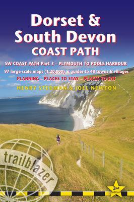
This guide covers the third and last section of the South West Coast Path, from Plymouth to Poole Harbour (217 miles). This beautiful route includes 95 miles within England's only Natural World Heritage Site, the Jurassic Coast, and passes dramatic cliffs and headlands, Chesil Bank's impressive spit and Lulworth Cove, winding through idyllic seaside villages such as Beer and Lyme Regis.- 97 maps large-scale walking maps - at just under 1:20,000 - with unique mapping features: walking times, directions, tricky junctions, places to stay and eat, points of interest. These are not general-purpose maps but fully-edited maps drawn by walkers for walkers.- Itineraries for all walkers - whether walking the route in its entirety or sampling the highlights on day walks and short breaks- Practical information for all budgets - Where to stay (campsites, hostels, B&Bs, pubs and hotels), where to eat, what to see- Comprehensive public transport information for day walks - all access points on the path- Downloadable gps waypoints
Citește mai mult

95.13Lei

95.13Lei

Primești 95 puncte

Important icon msg

Primești puncte de fidelitate după fiecare comandă! 100 puncte de fidelitate reprezintă 1 leu. Folosește-le la viitoarele achiziții!

Livrare in 2-4 saptamani

Descrierea produsului

This guide covers the third and last section of the South West Coast Path, from Plymouth to Poole Harbour (217 miles). This beautiful route includes 95 miles within England's only Natural World Heritage Site, the Jurassic Coast, and passes dramatic cliffs and headlands, Chesil Bank's impressive spit and Lulworth Cove, winding through idyllic seaside villages such as Beer and Lyme Regis.- 97 maps large-scale walking maps - at just under 1:20,000 - with unique mapping features: walking times, directions, tricky junctions, places to stay and eat, points of interest. These are not general-purpose maps but fully-edited maps drawn by walkers for walkers.- Itineraries for all walkers - whether walking the route in its entirety or sampling the highlights on day walks and short breaks- Practical information for all budgets - Where to stay (campsites, hostels, B&Bs, pubs and hotels), where to eat, what to see- Comprehensive public transport information for day walks - all access points on the path- Downloadable gps waypoints
Citește mai mult

De același autor

Părerea ta e inspirație pentru comunitatea Libris!

Istoricul tău de navigare

Noi suntem despre cărți, și la fel este și

Newsletter-ul nostru.

Abonează-te la veștile literare și primești un cupon de -10% pentru viitoarea ta comandă!

*Reducerea aplicată prin cupon nu se cumulează, ci se aplică reducerea cea mai mare.

Mă abonez image one
Mă abonez image one
Accessibility Logo