


Blue Ridge Parkway
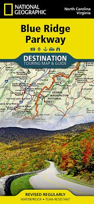
Blue Ridge Parkway
- Waterproof - Tear-Resistant - Travel Map
The Blue Ridge Parkway is a winding route that traverses some of America's most picturesque scenery. The Parkway is America's most visited National Park unit and when combined with Skyline Drive through Shenandoah National Park, also covered in detail on this map, a travel experience of over almost 600 miles is created. The Blue Ridge Parkway starts in the south at the foot of the Great Smoky Mountains and runs along the Blue Ridge through several National Forests from North Carolina and into Virginia.
National Geographic's Blue Ridge Parkway Destination Map strikes the perfect balance between map and guidebook and is ideal for a wide range of travelers. Destination Maps combine finely detailed maps with fascinating and practical travel information. The front side features a large-scale map of the Blue Ridge Parkway in North Carolina and Virginia and Skyline Drive in Virginia, richly layered with travel information and beautiful photographs showcasing some of many ways travelers can experience the road known as "America's Favorite Drive". In addition to the easy-to-read map on the front, the reverse side includes regional descriptions, arts and culture finds, and visitor resources. Explore detailed insets of the Great Smoky and Shenandoah National Parks.
Some of the extra features include:
- Charts detailing visitor centers and nearby state parks
- Colorful photographs featuring the region's enchanting landscape
- History, leaf viewing, wildflowers, wildlife, and places to visit
- Descriptive content highlighting outdoor recreation opportunities, water recreation, camping, hiking, and the Appalachian Trail
Every Destination Map is printed on durable synthetic paper, making them waterproof, tear-resistant and tough -- capable of withstanding the rigors of any kind of travel.
- Map Scale = 1:800,000
- Sheet Size = 25.5" x 37.75"
- Folded Size = 4.25" x 9.25"
PRP: 101.59 Lei
Acesta este Pretul Recomandat de Producator. Pretul de vanzare al produsului este afisat mai jos.
91.43Lei
91.43Lei
101.59 LeiPrimesti 91 puncte

Indisponibil
Descrierea produsului
- Waterproof - Tear-Resistant - Travel Map
The Blue Ridge Parkway is a winding route that traverses some of America's most picturesque scenery. The Parkway is America's most visited National Park unit and when combined with Skyline Drive through Shenandoah National Park, also covered in detail on this map, a travel experience of over almost 600 miles is created. The Blue Ridge Parkway starts in the south at the foot of the Great Smoky Mountains and runs along the Blue Ridge through several National Forests from North Carolina and into Virginia.
National Geographic's Blue Ridge Parkway Destination Map strikes the perfect balance between map and guidebook and is ideal for a wide range of travelers. Destination Maps combine finely detailed maps with fascinating and practical travel information. The front side features a large-scale map of the Blue Ridge Parkway in North Carolina and Virginia and Skyline Drive in Virginia, richly layered with travel information and beautiful photographs showcasing some of many ways travelers can experience the road known as "America's Favorite Drive". In addition to the easy-to-read map on the front, the reverse side includes regional descriptions, arts and culture finds, and visitor resources. Explore detailed insets of the Great Smoky and Shenandoah National Parks.
Some of the extra features include:
- Charts detailing visitor centers and nearby state parks
- Colorful photographs featuring the region's enchanting landscape
- History, leaf viewing, wildflowers, wildlife, and places to visit
- Descriptive content highlighting outdoor recreation opportunities, water recreation, camping, hiking, and the Appalachian Trail
Every Destination Map is printed on durable synthetic paper, making them waterproof, tear-resistant and tough -- capable of withstanding the rigors of any kind of travel.
- Map Scale = 1:800,000
- Sheet Size = 25.5" x 37.75"
- Folded Size = 4.25" x 9.25"
De pe acelasi raft
-

PRP: 80.53 Lei
72.48 Lei
72.48 Lei80.53 Lei
-
PRP: 116.17 Lei
104.55 Lei
104.55 Lei116.17 Lei
-
PRP: 102.99 Lei
92.69 Lei
92.69 Lei102.99 Lei
-
PRP: 260.10 Lei
234.09 Lei
234.09 Lei260.10 Lei
-
PRP: 118.52 Lei
106.67 Lei
106.67 Lei118.52 Lei
-
PRP: 148.73 Lei
133.86 Lei
133.86 Lei148.73 Lei
-
Amazing Asheville: Travel Guide to Asheville and the North Carolina Mountains (3rd ed.) - Lan Sluder
PRP: 167.09 Lei
150.38 Lei
150.38 Lei167.09 Lei
-
PRP: 136.33 Lei
122.70 Lei
122.70 Lei136.33 Lei
-
PRP: 223.89 Lei
201.50 Lei
201.50 Lei223.89 Lei
-
PRP: 305.49 Lei
274.94 Lei
274.94 Lei305.49 Lei
-
PRP: 142.53 Lei
128.28 Lei
128.28 Lei142.53 Lei
-
PRP: 458.49 Lei
412.64 Lei
412.64 Lei458.49 Lei
-
PRP: 130.13 Lei
117.12 Lei
117.12 Lei130.13 Lei
-
PRP: 111.53 Lei
100.38 Lei
100.38 Lei111.53 Lei
-
PRP: 159.06 Lei
143.15 Lei
143.15 Lei159.06 Lei
-
PRP: 152.39 Lei
137.15 Lei
137.15 Lei152.39 Lei
-
PRP: 136.33 Lei
122.70 Lei
122.70 Lei136.33 Lei
-
PRP: 254.49 Lei
229.04 Lei
229.04 Lei254.49 Lei
